
This page is a short primer — not a full textbook. It defines surveying, the two main divisions, how we measure, and the order of work you will see in the field and office. For AP cadastral procedure, use the guides hub and the toolkit calculators linked at the end.
1. What surveying is
Surveying determines the relative positions of points on, above, or below the Earth’s surface using linear and angular measurements. The products are maps, plans, cross-sections, and control points for engineering or cadastral work.
Levelling is the part of surveying that finds relative heights (elevations) between points.
Two jobs are always linked:
- Surveying (data collection): measure what is on the ground.
- Laying out (setting out): put design points back onto the ground (building corners, road centre lines, plot pegs).
2. Why we survey
- Village and cadastral maps (boundaries, fields, house sites)
- Engineering plans (roads, canals, tanks, buildings)
- Topography (hills, streams, contours)
- Control networks for later, less precise surveys
3. Plane surveying vs geodetic surveying
| Plane surveying | Geodetic surveying | |
|---|---|---|
| Earth curvature | Ignored (surface treated as flat) | Accounted for |
| Typical extent | Relatively small areas (classically < ~250 km²) | Large networks and long distances |
| Angles / distances | Plane geometry | Spherical / ellipsoidal geometry |
| AP day-to-day work | Most village / mandal cadastral and engineering surveys | High-order control, large state frameworks |
4. Reference surfaces (minimal)
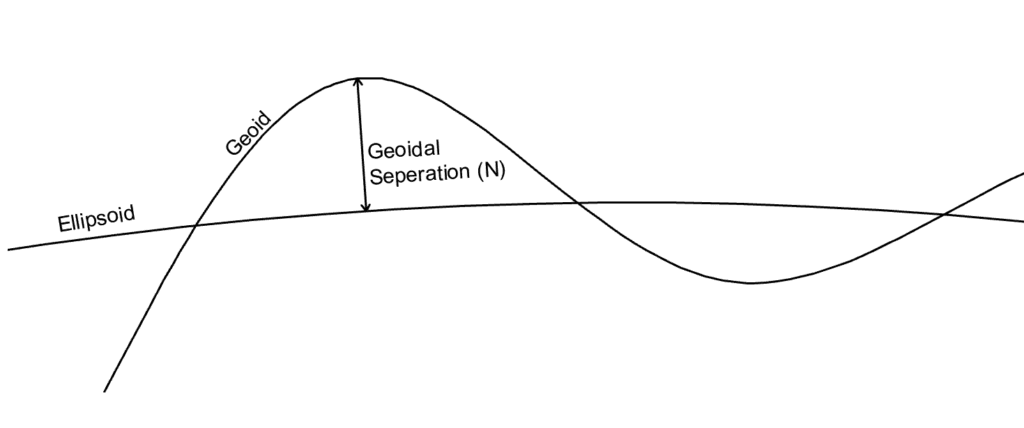
- Geoid — equipotential surface close to mean sea level; gravity-based; irregular.
- Ellipsoid — smooth mathematical Earth model for coordinates (latitude, longitude, ellipsoidal height).
- Geoid–ellipsoid separation (N) relates orthometric (spirit-level) height to ellipsoidal height.
For chain survey of a village field you mostly work in a local plane with chain and offset. For GNSS / CORS work you must know which datum and projection you are using.
5. Two fundamental principles
5.1 Work from whole to part
Establish accurate control first (outer framework), then fill detail with simpler methods. Errors stay inside the control net instead of growing across the whole survey.
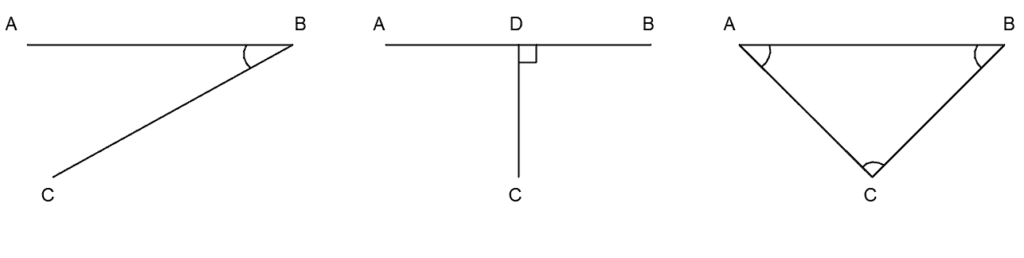
5.2 Fix a new point by at least two measurements
From known points A and B, locate C by one of:
- Distance + angle
- Two distances (intersection)
- Perpendicular offset from a line (chainage + offset)
6. How surveys are classified
6.1 By instrument (common set)
| Survey type | Main idea |
|---|---|
| Chain survey | Linear measurements; detail by offsets from chain lines |
| Compass survey | Bearings + chain lengths (traverse) |
| Plane table | Map drawn in the field while observing |
| Theodolite / total station | Precise angles (and EDM distances on total station) |
| Levelling | Height differences with level + staff |
| GPS / GNSS | Absolute / differential satellite positions (CORS, RTK) |
| Photogrammetry / remote sensing | Maps and measurements from images |
6.2 By method
- Triangulation — network of triangles; angles measured carefully
- Traverse — connected lines (open or closed) with angles and lengths
6.3 By object (examples)
- Cadastral — property and field boundaries
- Topographical — natural and cultural features
- Engineering — design and construction of works (recon → preliminary → location)
- Geological, mine, military, city utility surveys, etc.
7. Units (linear and angular)
- Linear (SI): metre, millimetre. Older records may use feet, links, or chains — convert before mixing systems. Use the unit converter.
- Angular (sexagesimal): 1° = 60′, 1′ = 60″. Centesimal grads and time measures appear in specialised work.
| Measurement | Typical instruments |
|---|---|
| Linear | Chain, tape, EDM, total station, GPS baselines |
| Angular | Compass, theodolite, total station, clinometer |
8. Stages of a survey job
- Field work
- Reconnaissance — choose stations and control
- Observations — distances, angles, levels, detail
- Field record — field book / digital log (primary evidence)
- Office work — reduce data, adjust small errors, plot plans, compute areas/volumes
- Care of instruments — protect from sun/rain, clean optics, use cases for transport, never leave instruments unguarded on roads
9. Scales (plans and maps)
- RF (representative fraction) = map distance / ground distance (same units).
- Large scale (e.g. 1:1000) → more detail for layouts and FMB-style plans.
- Small scale → overview maps. Always write the scale on the sheet.

Corrections & questions
These guides are maintained for practising AP surveyors. If a step is outdated or wrong, tell us — we prioritise field corrections.
Comments are not stored on this page. The report form attaches this URL automatically.